Salesforce Lightning Map: LWC & Google Maps 2026 Guide

⏱ 3 min read
The Salesforce Lightning Map Component is a robust geolocation and geospatial mapping solution that allows organizations to display customer locations, field service routes, territories, branch offices, assets, and GPS coordinates directly within Salesforce Lightning Experience. Powered by Google Maps API integration, the native lightning-map Lightning Web Component (LWC) enables businesses to create highly interactive and data-driven CRM experiences.
Businesses using Salesforce CRM increasingly rely on location intelligence, geospatial visualization, and map-based analytics to optimize customer engagement, territory management, logistics, sales planning, and field operations. The lightning-map component simplifies map integration inside Salesforce by providing developers with a native and scalable geospatial solution powered by Google Maps.
What is the Salesforce Lightning Map Component for Geospatial CRM?
The lightning-map component is a standard Salesforce Lightning component that enables developers to display interactive maps using Google Maps services. It supports plotting markers using:
- Latitude and longitude coordinates for precise mapping
- Geocoded addresses for location intelligence
- City, state, postal code, and country values
- Custom map markers and scalable vector icons
- Interactive marker selection events for dynamic workflows
- Territory mapping and location-based CRM visualizations
The component is widely used in Salesforce Field Service, Sales Cloud, Service Cloud, Experience Cloud, and custom Lightning Web Component (LWC) applications.
Salesforce Lightning Map API Features & Visualization Overview
| Feature | Description | Business Benefit |
|---|---|---|
| Google Maps Integration | Uses Google Maps as the visualization layer | Familiar and interactive UI |
| Map Markers | Displays customer or asset locations | Improves visibility and planning |
| Custom Icons | Supports SVG-based marker icons | Better branding and UX |
| Interactive Zooming | Zoom and pan controls | Improved navigation experience |
| Marker Selection Event | Tracks marker click interactions | Supports custom workflows |
| Lightning Compatibility | Works seamlessly in Lightning Experience | Rapid enterprise adoption |
Advanced Geospatial Features of lightning-map Component
Interactive User Experience
Users can interact with maps using zooming, panning, marker clicks, and responsive scaling for a seamless CRM experience.
Address Geocoding
Automatically converts text addresses into map coordinates using reliable Google geocoding API services.
Custom Marker Styling
Customize marker appearance with scalable vector icons, brand colors, anchor points, and informative labels.
Location Intelligence
Visualize customer distribution, field operations, sales territories, and regional service coverage areas.
Enhance Mapping with Salesforce Field Service Lightning: Features and Benefits
The lightning-map LWC component is a foundational element for mobile workforce management, perfectly complementing Salesforce Field Service Lightning (FSL). By integrating these robust geospatial mapping tools, businesses can unlock unparalleled workforce optimization, dynamic route optimization, and intelligent AI scheduling. Mastering field service management ensures that your dispatchers and mobile workers have the real-time location tracking data they need to deliver exceptional, on-time customer service.
Want to explore how FSL can transform your dispatching and mobile operations? Check out our complete guide on Salesforce Field Service Lightning: Features and Benefits.
Understanding the Salesforce Field Service Lightning Data Model
To properly render customer locations and service routes using the Salesforce lightning-map API, developers need a deep understanding of the Salesforce Field Service Lightning Data Model. This highly relational CRM data structure securely connects critical backend objects like Work Orders, Service Appointments, Service Territories, and Service Resources. A well-architected field service database ensures that your map markers reflect accurate, up-to-the-minute operational and geospatial data.
If you want to know more about the underlying FSL architecture and how location data flows between these objects, check out our deep dive into the Salesforce Field Service Lightning Data Model.
Important lightning-map Attributes for LWC Developers
| Attribute | Purpose |
|---|---|
map-markers |
Stores map marker data |
center |
Defines initial map center |
zoom-level |
Controls default zoom level |
markers-title |
Displays marker list heading |
selected-marker-value |
Highlights selected marker |
onmarkerselect |
Captures marker selection events |
How to Implement lightning-map in Salesforce LWC
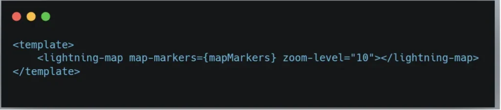
- Create a Lightning Web Component.
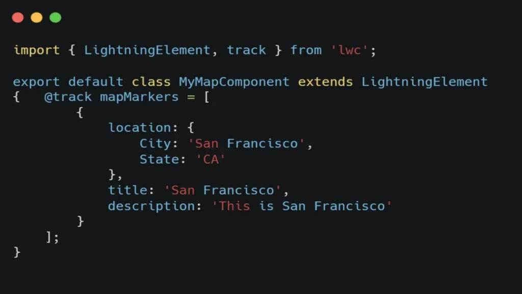
- Define geospatial map markers inside JavaScript.
- Pass marker array to
map-markers. - Configure zoom level and center coordinates.
- Handle marker selection using
markerselectevent. - Deploy component to Lightning App Builder.
Salesforce Lightning Map HTML Example
Salesforce Lightning Map JavaScript Example
Top Salesforce Lightning Map Use Cases for Field Service & Sales
Sales Territory Mapping
Visualize account territories and regional sales coverage.
Visualize account territories and regional sales coverage.
Field Service Management
Track mobile technicians, service appointments, and field routes.
Track mobile technicians, service appointments, and field routes.
Customer Location Tracking
Display customers and prospects geographically inside Salesforce CRM.
Display customers and prospects geographically inside Salesforce CRM.
Retail Store Locator
Create interactive branch and store finder experiences.
Create interactive branch and store finder experiences.
Asset Monitoring
Track inventory, technical equipment, and distributed CRM assets.
Track inventory, technical equipment, and distributed CRM assets.
Logistics & Dispatching
Optimize delivery routes and operational efficiency using location intelligence.
Optimize delivery routes and operational efficiency using location intelligence.
Limitations of Salesforce lightning-map
- Supports limited shape types like circle, rectangle, and polygon.
- Advanced GIS-level geospatial styling is unavailable.
- Only supports
markerselectevents. - Maximum performance optimization is around 100 markers.
- Google Maps regional restrictions may impact availability.
- Complex marker rendering can reduce LWC responsiveness.
- Limited advanced event handling like drag-and-drop or hover.
Best Practices for Salesforce Lightning Map Integration
- Use precise GPS coordinates instead of text addresses for higher accuracy.
- Validate all CRM marker data before rendering.
- Use lightweight SVG icons for better rendering performance.
- Cluster nearby map markers for large datasets.
- Optimize Google Maps geocoding requests to avoid API limitations.
- Leverage Lightning Data Service for efficient record retrieval.
- Ensure CSP configuration allows Google Maps rendering.
Frequently Asked Questions (FAQs) about Salesforce Lightning Map:
1. What is Salesforce Lightning Map?
The Salesforce Lightning Map component is a native Lightning Web Component that integrates Google Maps inside Salesforce applications for location visualization, routing, and mapping.
2. Does lightning-map support Google Maps?
Yes. The component natively uses Google Maps services for rendering maps and geocoding addresses.
3. Can I use custom markers in lightning-map?
Yes. Salesforce developers can create custom SVG-based map icons using the mapIcon property.
4. What is the maximum number of markers supported?
Salesforce recommends optimizing LWC implementations around 100 markers for best UI performance.
5. Can lightning-map work inside Experience Cloud?
Yes. The component can be used seamlessly inside Experience Cloud, Lightning App Builder, and custom LWC applications.
6. Does lightning-map support real-time tracking?
Yes. Combined with Apex, APIs, and Salesforce integrations, the component can support near real-time location tracking updates.
7. What industries use Salesforce Lightning Map?
Industries including healthcare, logistics, retail, field service management, real estate, manufacturing, and transportation use Salesforce map integrations extensively.
8. Can I integrate external geolocation APIs?
Yes. Salesforce developers can integrate external mapping APIs and geospatial services alongside lightning-map for advanced GIS capabilities.
Conclusion
The Salesforce Lightning Map Component is one of the most effective solutions for integrating Google Maps inside Salesforce Lightning Experience. From customer visualization and territory planning to robust field service management and logistics optimization, lightning-map empowers organizations with real-time location intelligence directly within CRM workflows.
By leveraging Lightning Web Components (LWC), Google Maps API integration, and Salesforce geospatial capabilities, businesses can create modern, scalable, and highly interactive enterprise applications that improve operational efficiency, routing, and customer experiences.
Need Help with Salesforce Lightning Map Integration?
Kizzy Consulting specializes in Salesforce Lightning Web Components, Google Maps API integration, Salesforce geolocation solutions, Field Service Lightning implementations, and enterprise-grade CRM development.
Our Salesforce experts help businesses build scalable map-based CRM applications with advanced geospatial visualization, territory intelligence, route optimization, and real-time tracking capabilities.
Contact us at
[email protected]
or visit
Kizzy Consulting
to discuss your Salesforce integration and Lightning development requirements.